
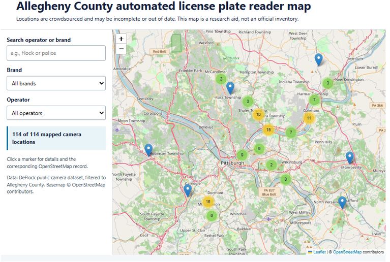
Key Finding: The Allegheny Data Institute’s first DeFlock-derived snapshot identifies 114 mapped automated license plate reader (ALPR) locations within Allegheny County. The locations are not an official inventory and should be understood as a minimum count of cameras documented in this particular public dataset—not a count of every camera operating in the county.
What the Data Shows: The mapped locations span multiple parts of Allegheny County and include cameras with several reported brands and operators. Most records do not include a listed operator or brand. That missing information does not mean a camera lacks an operator or manufacturer; it means those details were not present in the public record used for this snapshot.
The map records a camera’s geographic coordinates and, when available, its brand, operator, direction, surveillance zone, and mount type. Each record links back to its OpenStreetMap entry, allowing readers to inspect the underlying public map record.
The 114 locations are useful for asking practical local questions: Where are documented ALPRs concentrated? Which public agencies or private entities are listed as operators? Which areas have little or no public documentation? The current data cannot answer all of those questions completely, because its coverage depends on voluntary reporting and the detail supplied with each report.
Analysis: ALPRs are cameras designed to capture and process license plate information. Their presence can have public-safety applications, but it also raises civic questions about surveillance, data sharing, retention, access, oversight, and whether residents know where systems are operating.
Mapping is not, by itself, an answer to those questions. It is a starting point for public understanding. A transparent, community-maintained map makes it easier for residents, journalists, researchers, and public officials to distinguish between what is documented and what remains unknown.
The main limitation is completeness. DeFlock’s own public county summary currently reports a higher county-level count than the 114 records in the downloadable snapshot used here. That difference may reflect different update times, data pipelines, or counting methods. For that reason, this brief does not estimate the county’s total number of ALPRs, compare municipalities by camera count, or treat an unmapped area as camera-free.
Call to Action: Help Document What Is There: Residents can improve the public record by reporting cameras they can identify safely and accurately. DeFlock offers two reporting paths at deflock.org/report: its mobile app for iOS and Android, and OpenStreetMap’s web editor for more detailed submissions.
If you choose to contribute:
- Report only cameras you can observe from a lawful public location. Do not trespass, interfere with equipment, or stop in an unsafe place.
- Confirm the physical location before submitting it. A precise location is more useful than a guess.
- Use DeFlock’s identification gallery and reporting instructions to select the appropriate camera type and tags.
- Add the direction the camera faces when you can determine it, and include a public image only when you have the right to share it.
- Avoid including personal information, license plates, or other unnecessary details in a report.
Community reporting is most valuable when it is careful. A public map should make surveillance infrastructure more legible, not spread speculation. Every accurately documented location helps create a stronger basis for informed local discussion.
Method: This brief uses the DeFlock public camera dataset mirrored in the project’s public map repository. Records were retrieved on August 27, 2026 and filtered to the Allegheny County, Pennsylvania boundary (Census GEOID 42003) using a point-in-polygon method. The resulting file contains 114 records.
The data are crowdsourced and based on OpenStreetMap records. A mapped point indicates that a contributor documented a camera location; it does not independently verify that the camera is active, operated by a particular entity, or capable of any particular function. Records may be missing, duplicated, changed, or removed as the underlying map is updated.
Sources
- DeFlock, Report Cameras, accessed August 27, 2026.
- DeFlock public map repository, FoggedLens/deflockhopper_maps, camera dataset and county boundary layer, retrieved August 27, 2026.
- OpenStreetMap contributors, OpenStreetMap.
Leave a Reply